Thursday, August 6, 2015

Animas River Mine Sediment Pictures above Durango

Tonight around 7:30 the sediment plume made it to Durango, although somewhat dilute from what was witnessed upstream. Much of the sediment is falling out of the water as the river meanders through the valley north of town and the river turbulence quiets. It will likely take a couple of days for the main portion of this to pass Durango completely. Keep in mind that the impacts from this event will take a long time to clear up and we will likely see this sediment stirred up with the rise and fall of the river. Given the river flows at this time of year and the slow movement from north to south, operators have had lots of time to shut down drinking and agricultural water diversions along the Animas including city of Durango water. What happens next will be determined by the test results from the EPA tomorrow.

Until we have a clear picture of the hazard, stay on the side of caution and stay out of the river.

We have word that Cement Creek and the Animas near Silverton are clearing up a bit tonight.

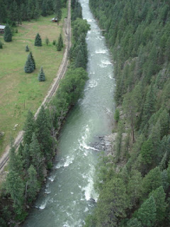
Here are some pictures of the sediment flow near Baker's Bridge today.


This aerial is from KOB tv. See their video HERE

Note how much sediment settled after 12 minutes 

These are from this morning south of Baker's Bridge at the East Animas Canal Diversion


TM


Animas River is Closed until Further Notice

Effective Thursday, August 6, 2015 at 3:00 p.m., La Plata County Sheriff Sean Smith issued an order pursuant to CRS 33-13-111 and 112, closing the Animas River to all watercraft including canoes, kayaks, tubes, rafts and other flotation devices from the north County line (San Juan County, Colorado) to the south County line (at the Colorado/New Mexico State line) until further notice.  Furthermore, all such watercraft must be removed from the Animas River within the locations cited above.  
 
“This decision was made in the interest of public health after consultation with the Environmental Protection Agency, the Colorado Department of Health and Environment, San Juan Basin Health Department and representatives of the Southern Ute Indian Tribe,” advised Sheriff Sean Smith.  “This Order shall remain in effect until it is determined that the river is safe.  EPA test results of the Animas River are expected within 24-48 hours, and the Order will be re-evaluated at that time.”  
 
The City of Durango and La Plata County Sheriff’s Office are posting notices along the Animas River to notify citizens.   
 
A Call Center has been set up for the public at 970-385-8700.  As additional information is received, it will be posted to the La Plata County website at http://www.co.laplata.co.us/emergency, San Juan Basin Health Department’s Website at www.sjbhd.org, La Plata County Government Facebook and San Juan Basin Health Department Facebook.

Gold King Mine release of water will affect Durango this afternoon

Yesterday, the EPA and State Division of Reclamation, Mining and Safety team working to investigate and address contamination at the Gold King Mine in San Juan County, Colo. unexpectedly triggered a large release of mine waste water into the upper portions of Cement Creek.  Initial estimates are that the release contained approximately 1 million gallons of water that was held behind unconsolidated debris near an abandoned mine portal.  There were several workers at the site at the time of the breach, all were unharmed.  
 
The EPA recommends that recreational users of the Animas River avoid contact with or use of the river until the pulse of mine water passes.
 
The acidic mine water associated with the release contains high levels of sediment and metals.  EPA teams are conducting sampling and visual observations today and will be monitoring river conditions over the next several days.  The water associated with the release is obvious and highly discolored. 
 
This mine waste water was sighted at Baker’s Bridge (north of Durango) early this morning.  It is estimated that it will arrive within the city limits of Durango by approximately 3:00 p.m.
 
La Plata County Office of Emergency Management, La Plata County Sheriff’s Office, San Juan Basin Health Department and City of Durango have been monitoring the issue since yesterday.  Local officials will be working to notify recreational users to avoid contact with the river until further notice.  All agricultural water users have been notified to shut off water intake.  It is recommended that pet owners keep their dogs and livestock out of the Animas River until further testing can be done to determine the content of the waste water.
 
Joe Lewendowski, Public Information Officer for Colorado Parks and Wildlife in Durango said, “Colorado Parks and Wildlife biologists are monitoring the impacts to the fish and other wildlife in the Animas River.” 
 
A Call Center has been set up for the public at 970-385-8700.  As additional information is received, it will be posted to the La Plata County website at http://www.co.laplata.co.us/emergency, San Juan Basin Health Department’s Website at www.sjbhd.org, La Plata County Government Facebook and San Juan Basin Health Department Facebook.


Friday, June 26, 2015

2015-06-24 Upper Animas Lower Rapids and Gorge Search


SAR Search/Recovery 2015-06-24
Subject last seen in Upper Animas Rapids
Ingress: At or below Tank Creek
Last Seen Point: South end of Ah Wilderness Camp

The following pictures were made 6-21-2007 during an aerial survey performed by La Plata County SAR, OEM and Sheriff's Department to assist in future searches/rescues/recoveries such as today. The complete Upper Animas photo catalog are included in this Google Earth File with landmarks, rapids, and RR info along the river.


3421 At or Near Ingress at Tank Creek

3422 through 3428 Along Animas River from Tank Creek through 
3423


3424
3426

3427

3428 Bridge at Ah Wilderness

3442 Animas River from below MP474 

3466 Beginning of HighLine 


3468 The remainder of photos are of the Animas Gorge
3495

3499

3504

3509

3518

3524 Log Jam

3526

3531

3535

Friday, June 12, 2015

High Water Continues in La Plata County, but no road closures or evacuations

Officials from several agencies have continued to monitor high water conditions on several streams and rivers in La Plata County.  No evacuations have been made, but some property owners downstream of Vallecito Reservoir have reported minor flooding and water in areas where there has been no water in recent years.  Yesterday, the Upper Pine Fire Protection District filled over 200 sandbags for homes and worked hard to remove debris from bridges along the Pine River to ensure bridge integrity and prevent flooding around the bridges.  The La Plata County Sheriff’s Office patrolled the Pine River below the Vallecito Reservoir watching bridges and flow to ensure safety.

The National Weather Service has a flash flood watch in place for La Plata County.  A flash flood watch means that conditions may develop that lead to flash flooding.  Heavy rain is still in the forecast for the next few days.  Forecasters are expecting storms today that could produce ¼ to ¾ inch of precipitation.  Additional thunderstorms are expected Saturday afternoon and scattered showers are forecasted for Sunday.  In anticipation of the additional moisture from these storms, the heavy discharge out of Lemon and Vallecito Reservoirs will continue for the next few days depending upon weather patterns, moisture accumulations and upper elevation temperatures in the headwater areas of the streams.  If rain falls on snow in the high elevations, it could cause a noticeable increase in the snowmelt resulting in high runoff into the streams.

Lemon and Vallecito Reservoirs were nearing full capacity when we received the late season, heavy snow accumulation in the headwaters of streams and rivers that pass through La Plata County and two tropical weather systems this month that created significant increases to the inflows going into the reservoirs.  Consequently, operators of those two irrigation structures had to make room for the additional water by discharging large volumes of water out of the reservoirs.  This has led to significant flows downstream of the reservoirs.  As a result, property owners below the reservoirs are experiencing larger water volumes in the Florida and Pine Rivers as water is released to create additional retention capacity in the reservoirs.  These large, controlled discharges are intended to prevent larger, uncontrolled flooding out of the reservoirs. 

No other significant issues have been reported for County Roads overnight, but motorists are urged to drive carefully as they may encounter debris and mud on the roads.  Motorists should not drive into areas where the water covers the roadway. The water depth may be too great to allow a safe crossing. If flooding is observed, act quickly. Do not enter the water. Turn around and move up to higher ground.

“There has been an excellent multi-agency process that has brought many professionals to the table to observe and predict impacts from these conditions,” said Butch Knowlton, La Plata County Emergency Management Director.  “There is just not one expert that can address all of the issues that this type of event creates.  Therefore all of those people coming together to share their expertise and knowledge has been impressive, and very much appreciated.”

Some of the agencies coordinating the efforts include: Pine River Irrigation District, Bureau of Reclamation, Colorado Division of Water Resources, Dam Safety Office in Denver, National Weather Service, NOAA, Colorado River Basin Forecast Center, Upper Pine Fire Protection District, Los Pinos Fire Protection District, Bayfield Marshal, CDRC Corps of Engineers, Southern Ute Tribal Officials, US Forest Service Columbine and San Juan Hotshots, La Plata County Road and Bridge, La Plata County Office of Emergency Management and Sheriff’s Department, La Plata County Search and Rescue, and numerous ditch companies and water users.
.

The National Weather Service is the best source for weather updates.  Visit them online at www.weather.gov/.  

Thursday, June 11, 2015

Update on High Water-no evacuations or road closures. Officials continue to monitor

Officials from several agencies continued to monitor high water conditions on several streams and rivers in La Plata County today.  These conditions were brought on by the late season, heavy snow accumulation in the headwaters of streams and rivers that pass through La Plata County and two tropical weather systems this month that created significant increases to the inflows going into the reservoirs.

In particular, the Vallecito and Pine River drainage areas that flow into Vallecito Reservoir have been closely monitored today.  Lemon and Vallecito Reservoirs were nearing full capacity when the additional precipitation accumulated in the river basins above the reservoirs.  Consequently, operators of those two irrigation structures had to make room for the additional water by discharging large volumes of water out of the reservoirs.  This has led to significant flows downstream of the reservoirs.  As a result, property owners below the reservoirs are experiencing larger water volumes in the Florida and Pine Rivers as water is released to create additional retention capacity in the reservoirs.  These large, controlled discharges are intended to prevent larger, uncontrolled flooding out of the reservoirs.  These high volume releases could continue, and possibly increase, for the next few days depending upon weather patterns and moisture accumulations and upper elevation temperatures in the headwater areas of the streams.  If rain falls on snow in the high elevations, it could cause a noticeable increase in the snowmelt resulting in high runoff into the streams.

The National Weather Service has downgraded the flash flood warning to a flash flood watch in La Plata County.  A flash flood watch means that conditions may develop that lead to flash flooding.  Today, .34 inches of rain fell at Lemon dam, but areas north of the dam received more rainfall.  Rainfall is expected to be minimal after midnight tonight and then more moisture is anticipated Friday afternoon.

No evacuations have been made, but some property owners downstream of Vallecito Reservoir have reported minor flooding and water in areas where there has been no water in recent years.  Upper Pine Fire Protection District has been working to sandbag at-risk homes along the Pine River and Upper Pine and officials have been constantly monitoring bridges for debris.

County Road 322 had some flooding over the road near La Boca this morning, but it is now clear.  No other significant issues have been reported on other County Roads, but residents are asked to be especially cautious at night when it is harder to recognize the dangers of flooding. Motorists are urged to drive slowly and carefully as they may encounter debris and mud on the roads.  Motorists should not drive into areas where the water covers the roadway. The water depth may be too great to allow a safe crossing. If flooding is observed, act quickly. Do not enter the water. Turn around and move up to higher ground.

“There has been an excellent multi-agency process that has brought many professionals to the table to observe and predict impacts from these conditions,” said Butch Knowlton, La Plata County Emergency Management Director.  “There is just not one expert that can address all of the issues that this type of event creates.  Therefore all of those people coming together to share their expertise and knowledge has been impressive, and very much appreciated.”

Some of the agencies coordinating the efforts include: Pine River Irrigation District, Bureau of Reclamation, Colorado Division of Water Resources, Dam Safety Office in Denver, National Weather Service, NOAA, Colorado River Basin Forecast Center, Upper Pine Fire Protection District, Los Pinos Fire Protection District, Bayfield Marshal, CDRC Corps of Engineers, Southern Ute Tribal Officials, La Plata County Road and Bridge, La Plata County Office of Emergency Management and Sheriff’s Department, La Plata County Search and Rescue, and numerous ditch companies and water users.
.
A Call Center has been set up for the public at 970-385-8700 and will be open until 8:00 p.m. tonight.  The National Weather Service is the best source for weather updates.  Visit them online at www.weather.gov/.  

High Water Conditions in La Plata County

“If you don’t believe the weather changes frequently in Colorado, just look at La Plata County!” said Butch Knowlton, La Plata County Emergency Management Director. 

Monday, April 13, 2015

Sign up for Emergency Notifications in La Plata County

The 2015 Fire season is upon us, get the emergency alerts...
The Durango-La Plata Emergency 911 Communications Center updated the Emergency 911 alerting system to CodeRED recently. The new system has many features that enhance our ability to create and distribute emergency alerts.
All land line phones are already included in the notification system. Cell phones, internet (IP) based phones and others are not.

If you had signed up for the previous system prior to January 2015 you will unfortunately have to sign up again for the new system.

Any information put in the system is exclusively for use to distribute emergency notifications from local Fire, Law Enforcement and Emergency Management.

Step 1: Go to co.laplata.co.us/emergency and follow the links or just hit HERE
Step 2: Add an address
Step 3: Add phones and emails
Step 4: Choose managed account (make a login), or verify only
Step 5: Verify info, you can even move the mapped address to exactly where your house is

Now you are fully connected!

CodeRED has a mobile app for Apple and Android devices
Get it HERE or search in the app store for your device
This is a separate system but will be connected to any CodeRED emergency alert through your location. This works in any community using CodeRED which is about 2/3 of Colorado! You can also add other alerts from the weather service and others which work anywhere you go.